Tom's Journal - Days 63-69, August 9 - August 15
Return to Alaska
A VERY busy week! But first…
How did the town of Chicken, Alaska get its name?
From last week's journal, I was asked "how did Chicken, Alaska get its name?" Well, there are two popular theories. The first, and the one I think is most likely, is that there was a gold miner / philosopher who had some issues with reality, but that isn't important. This gold miner, while working and protecting his gold claim, was trying to solve the age old question of why the chicken crossed the road. He considered all of the traditional answers such as "to get to the other side," "to clandestinely meet a rooster," and "to make a phone call." But none of these seemed to satisfy him. Then one day, he spotted a ptarmigan and thought it was a chicken. He saw this ptarmigan cross the road looking for gold in a nearby stream and it found some. That is when the miner said, "Eureka, I now know why the chicken crossed the road and I am going to call this town Chicken!"
The second, and less plausible explanation, is that the town founders wanted to name the town ptarmigan after the bird of Alaska (even though Alaska wasn't a state yet and didn't need a bird), but the town people had difficulty spelling ptarmigan and said, "oh heck, let's just call the dumb town Chicken."
And now you know!
Beginning in Dawson, followed by our drive to Whitehorse, and onto Skagway, we have been following the reverse route, as much as the highways allow, of the Klondike gold stampeders' path of 1897 to the Klondike goldfields. The stampeders arrived in Skagway, made their way from Skagway to Whitehorse, and then on to Dawson City and the Klondike goldfields.
The Gold Miners' Trail to the Klondike Goldfields with All Relevant Facts:
Well, in 1896, there were three dudes, George Washington Carmack, Keish ("Skookum Jim" Mason), and Kaa Goox (Dawson Charlie) who were out exploring creeks and streams in the Yukon and Klondike river area for gold. In the official records there isn't any mention of dudettes but George's wife Kate had to tag along. This was supposed to be a "boys night out" type of thing but Kate wouldn't allow George to go out by himself. On August 16, 1886, they were kicking rocks around in Rabbit Creek and spotted some gold. Carmack was the only white guy in the group and at the time, only white guys could file claims. Carmack filed the claim the next day, August 17, 50 miles down river at Fortymile, the nearest town. Therefore, Carmack gets all the credit in the history books for discovering gold and starting the Klondike Gold Rush stampede. His public relations guys renamed the creek to Bonanza Creek; they thought it sounded more catchy.
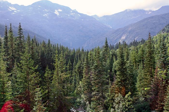
By the time the word got around about the gold in the Klondike, it was starting to get cold and most of the heap big men decided to wait in bars and tell tall tales until the spring of 1887 before starting to rush. The best way to get to the Klondike goldfields was through Skagway, Alaska and the White Pass Trail or next door through Dyea, Alaska and the Chilkoot Trail into Canada. However, Skagway and Dyea are surrounded by some pretty high coastal mountains. And to make maters worse, Canada and the North West Mounted Police required any miners entering Canada to have a year's worth of supplies, two thousand pounds per person. Now at this time, all of the jet planes were either grounded or not invented yet. The miners had no choice but to haul one ton of supplies each up either the Chilkoot Trail (33 miles) or the White Pass Trail (43 miles but less steep) however they could. There were some pretty inventive ways: backpacking, horses, dogs, hire natives, wheel barrels, a hot air balloon (it didn't make it), and even a bicycle. Hauling one ton required making numerous trips and caching the supplies about every 5 miles. The White Pass Trail was called the "Rich Man's Trail" and the Chilkoot the "Poor Man's Trail." On the Rich Man's Trail, the pass wasn't quite as steep and they could actually use pack horses, or so it was advertised. The steep section of the pass is called "Dead Horse Gulch" because over 3,000 horses died in the gulch from overwork.
Once the miners got their one ton of supplies up the 33-mile Chilkoot Trail or the 43-mile White Pass Trail to Lake Bennett and they were inspected by the Mounties, they had to build a boat, raft, or something else that floated and then float themselves and their supplies from Lake Bennett, through the connecting waterways, and to the Yukon River. Once on the Yukon River, they made their way down the Yukon, past Whitehorse (after stopping for a latte), and on to Dawson City. There were estimates of 100,000 people heading out on the gold rush quest but only about 30,000 actually made it to the goldfields. The rest either gave up, opened a gift shop along the way, or were distracted by one of the many gift shops that had sprung up in Skagway.
While over 30,000 made it to Dawson, only a few hundred actually had claims of any value and those went to miners already in the area before the stampeders even arrived. The 30,000 wound up working for claim owners or opening businesses in town to mine the miners' pockets. And, if all else failed, they opened a gift shop.
Some railroad enthusiasts decided it would be a much easier trek if they could build a railroad from Skagway to Whitehorse and call it the White Pass & Yukon Route or WP&YR railroad. Building of the railroad started in 1898 and was completed in the summer of 1900 just as the gold rush was petering out (because all the claims were staked and there wasn't room for anymore gift shops) but at that time the big mining companies were getting started and needed the railroad to haul equipment, people, and supplies. The WP&YR was also a key supply route during the building of the Alaska Highway during WWII. The WP&YR was eventually replaced by the Alaska Highway and the South Klondike Highway. Oh well, so much for helping build the Alaska Highway.
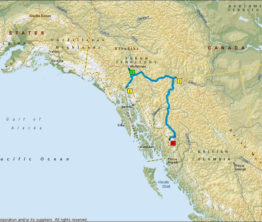
Our route this week:
We spent the weekend in 1-Whitehorse. On Tuesday, we drove to 2-Skagway for three nights. On Friday, we drove to 3-Watson Lake and on Saturday, we headed towards 4-Stewart (stopping Saturday night at Iskut).
Day 63 (Sunday, August 9)
Whitehorse. We attended church in the morning and in the afternoon went out to the Copperbelt Mining and Railway Museum to learn about copper mining in the region and to ride the little mine train around the park, ye ha!
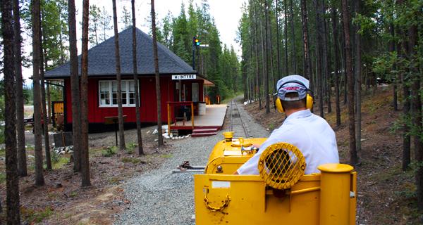 Our train ride at Copperbelt Mining and Railway Museum in Whitehorse |
Day 64 (Monday, August 10)
We finished our sightseeing in Whitehorse by going to the Yukon Transportation Museum that had some interesting exhibits on the various methods of travel through the years in the Yukon and then we went over to the Yukon Beringia Interpretive Centre that attempts to trace the Ice Age in the Yukon, not overly exciting.
|
Inside the Yukon Transportation Museum |
Day 65 (Tuesday, August 11)
Onward. We drove 110 miles from Whitehorse to Skagway, the Disneyland of the Alaska cruises. All Alaska cruises stop at Skagway. There are anywhere from 3-6 cruise ships in Skagway each day. The ships are behemoths that tower over the city from the docks. Each ship carries between 2-3,000 tourists. In the early mornings or late evenings Skagway is a fairly quiet and deserted town. But, by mid-morning, the ships disgorge their armies of thousands of tourists. The town comes alive with train rides, tours, and gift shops as far as the eye can see. All of the items in the gift shops, since the first cruise ship of the year enters port, are marked "season closeout," or "end-of-season manager special!"
So what did we do? ...Ah, we went to the gift shops. I got a coat, BUT IT WAS AN END-OF-SEASON MANAGER SPECIAL!
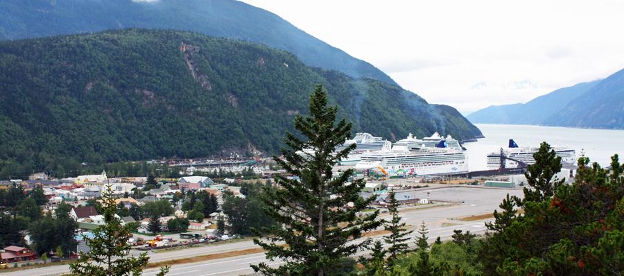 Skagway with four cruise ships in port |
Day 66 (Wednesday, August 12)
After "experiencing" the front lines of downtown Skagway yesterday afternoon, we drove over to the old town site of Dyea and took a tour of the town site with a National Parks' interpretive guide. It was interesting to hear the tale of the town. In 1897-1900, it had tens of thousands and competed with Skagway. Dyea was the port at the base of the Chilkoot Trail and Skagway was the port at the base of the White Pass Trail. While more miners took the Chilkoot Trail, with the completion of the WP&YR Railroad, all of the business moved to Skagway and Dyea was mostly deserted. Even the lumber from the buildings was taken to build in Skagway. So, there wasn't much to see at the old town site but the stories from the guide were great.
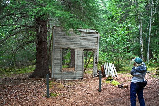
Becky taking picture of the remains at Dyea - the false front of a real estate office
In the afternoon, we took another guided tour from a National Parks' interpretive guide of the historical buildings of Skagway. We walked very carefully, amongst the throngs of tourists shopping, to various historic buildings, listened to some great stories, and got a sense of the gold rush period in rough Skagway.
In the evening, we joined the sea of tourists from the cruise ships for a ride on the WP&YR train from the station in Skagway up to the White Pass Summit and back. There were gorgeous views and it was fun to see the path that the miners had to trek.
 The White Pass Summit - miners had to haul their one ton of supplies from the sea port to this summit |
Day 67 (Thursday, August 13)
We got up early and took the Fjord Express to Juneau. This is a sightseeing tour that leaves Skagway at 8:00 AM on a 40-passenger boat. There was three-and-a-half hours of sightseeing and touring on the way to Juneau. Then there was a bus tour of downtown Juneau followed by three hours of free time for lunch and sightseeing and then a bus tour out to Mendenhall Glacier. Then a bus ride back to the boat for a three-and-a-half hour tour back to Skagway, our trip was a little longer due to some extra whale watching and didn't arrive back until 8:45 PM, a long day.
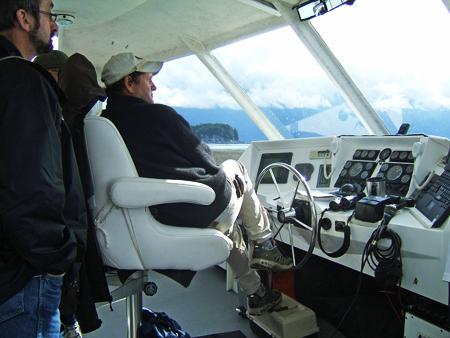 Captain Glenn in command of the Fjordland - our ride to Juneau |
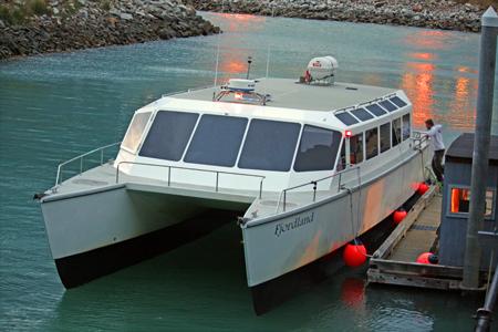 The Fjordland upon our return to Juneau |
The captain, owner, operator was great. And I will admit, I was taken in when he took us to see a bear cave that was actually a bare cave but nearby was a stream and there was a bear fishing for salmon. The captain was able to move the boat in rather close without startling the bear as we watched him for 15-20 minutes.
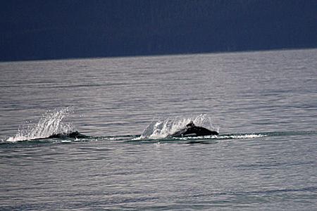
During our sightseeing we saw the bear, seals, Dall Porpoise, Stellar Sea Lions, bald eagles, and a couple of lighthouses.
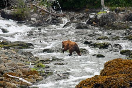 Bear fishing for salmon |
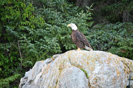 Majestic Bald Eagle |
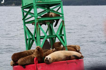 I'm king of the buoy! |
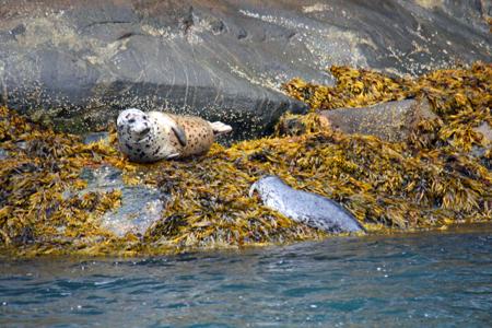 Mamma seal with pup |
 Two Dall's Porpoises |
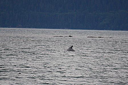 It's a humpback whale, trust me |
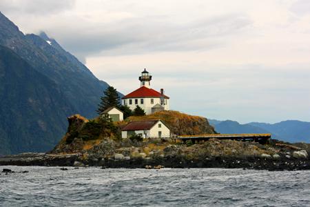 Lighthouse for sale by owner, US Coast Guard |
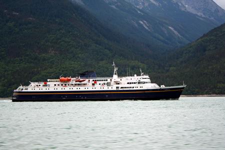 Ferry - a common method of transportation in British Columbia and Alaska |
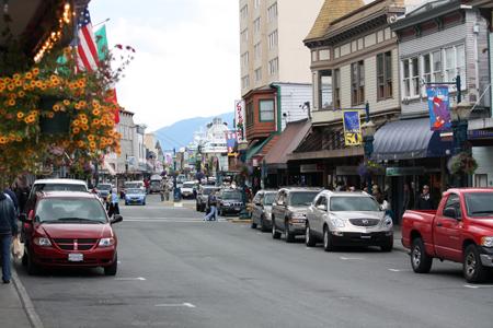 Downtown Juneau |
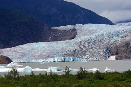 Mendenhall Glacier |
Day 68 (Friday, August 14)
Onward for a long day of driving. From Skagway, we drove 320 miles to Watson Lake where we stopped on our way along the Alaska Highway the first time, the home of the Sign Post Forest. On our way to Alaska, Watson Lake felt like we were fairly far north. Now, it feels like we are fairly well south and we are headed towards home, but not quite yet.
Day 69 (Saturday, August 15)
From Watson Lake we drove a rough dirty gravel road partway to Stewart and stopped at Iskut for the night.