Becky's Journal - Alaska Highway Part 1, June 14 - June 20
Becky is ready to start at Mile 0
Sunday, June 14, 2009
We attended the First Baptist Church of Dawson Creek
this morning. We felt very
welcomed and enjoyed the worship and fellowship immensely.
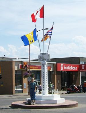
After lunch, we headed out to explore Dawson Creek,
the beginning point, Mile 0, of the Alaska Highway.
Built by the Army Corps of Engineers in 1942 as a means of
assuring the protection of Alaska from the Japanese who had captured
several of the outer Aleutian Islands, the military road provided a
means of outfitting and supplying U.S. military bases in Alaska.
First known as the AlCan Highway, the Alaska Highway spans close
to 1500 miles from Dawson Creek, British Columbia to Fairbanks, Alaska.
After World War II, the road continued to develop as a supply
route and means for voyagers (like Tom and me) to explore the rugged
beauty of our 50th state.
Alaska Highway:
Dawson Creek
Tuesday, June 16, 2009
After taking care of the necessities of life –
laundry, cleaning, routing planning, and shopping – on Monday in Dawson
Creek, Tuesday we were up early for the 300 mile drive to Fort Nelson.
The drive was pretty – forested hills, with gullies and culverts
along the road. Our wildlife
sightings doubled with a deer crossing the road in Charlie Lake and a
doe with two fawns along the road.
Alaska Highway:
Muncho Lake
Wednesday, June 17, 2009
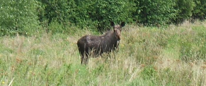
The scenery today outshone everything that we’d seen
so far – pristine mountain lakes and snow-topped Rocky Mountains.
Tooling down the road, Tom spotted a couple of moose just heading
out of the woods along the road.
We stopped and got some good pictures.
The moose were aware of us, but didn’t spook.
Early afternoon, we reached Summit Pass and Lake, the highest
elevation on the Alaska Highway.
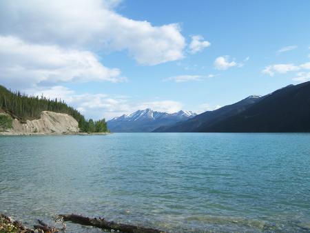
Late afternoon we arrived at Muncho Lake, high in the
Rockies, where we plan to spend three nights.
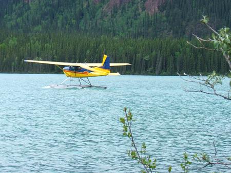
It is definitely worth the lakefront camping site (appreciate
your recommendation, Mom), where floatplanes dock out front and whisk
guests off to fish or see glaciers or views from above.
Exploring Muncho Lake
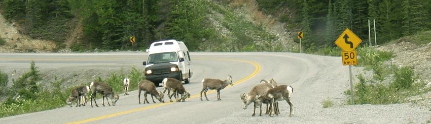
Thursday, June 18, 2009
Today has been a day of relaxing – exploring and short
hikes and watching the planes in front of our trailer site.
We drove to a couple of local viewpoints and were treated to a
herd of Stone Sheep tying up traffic on the road.
Stone Sheep are a smaller, darker-colored version of our Rocky
Mountain Big Horn Sheep. I
was surprised how close we could get to the sheep without startling
them, and the lambs were precious.
Friday, June 19, 2009
Another day at our relaxing campsite high in the
Rockies. The clarity and
color of the lake sparkled bright, and the calm waters this morning
reflected Mount Patterson and other surrounding mountains and clouds.
Alaska Highway:
Watson Lake
June 20, 2009
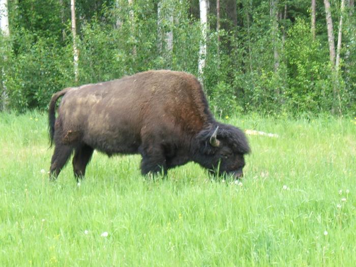
Lions, and tigers and bears, oh my!
Or maybe it was, bison and bears and cubs, for real!
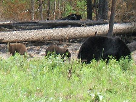
Today was a banner day for viewing wildlife along the road,
thanks to Tom’s eagle eyes.
Shortly after leaving Muncho Lake this morning, we spotted three wood
bison grazing along the verge, the green, grassy area that borders the
highway. Dozens of photos
later we got back underway.
Later, Tom spotted a black bear at the edge of the verge and still later
we saw a bear with two cubs meandering down the greenbelt.
(That was worth even more digital shots.)
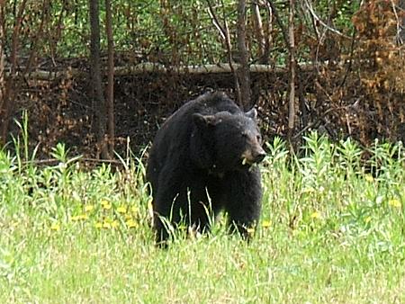
Mama Bear
Mama and Cubs
Down the road 168 miles, Watson Lake was our
introduction to Yukon Territory, a province of only about 30,000
inhabitants – most of whom live in the provincial capital of Whitehorse.
Watson Lake, with its 1500, has its charms and tourist
attractions. This afternoon,
we wandered through Signpost Forest, a renowned collection of road signs
and town markers (over 65,164) from around the globe.
It was begun by a homesick U.S. Army GI in 1942, who posted a
sign with mileage pointing to his Danville, IL hometown.
As we wandered, we managed to find Folsom, CA (with an outdated
population of 3,422), Carmel, IN, New Berlin, WI, Sacramento, CA,
Roseville, CA, and many European cities and towns.
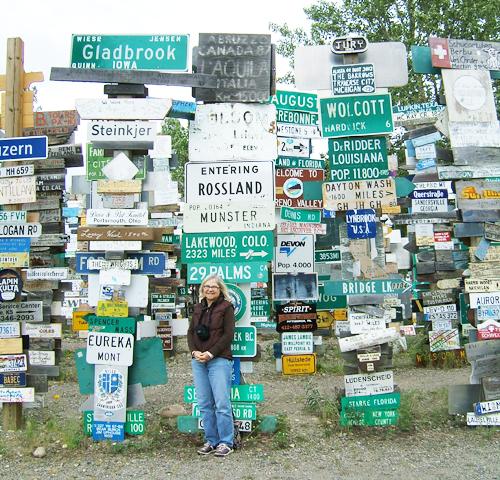
Becky below faded Folsom sign (second from top)
This evening, we visited the Northern Lights Centre,
which has a beautiful video presentation on the Aurora Borealis of the
Yukon and North. Planetarium
style, these photos showed the dancing red and green lights in the
northern skies, visible especially in the dark nights of winter.
And the road continues to beckon us northward…