Becky's Journal - August 9 - August 15
On the Road:
Whitehorse and Skagway
 Whitehorse
–Sunday, August 9, 2009
Whitehorse
–Sunday, August 9, 2009
We attended worship this morning at Whitehorse Baptist Church, right downtown across from the Yukon government building, which includes provincial administrative offices, the public library, and legislative chambers.
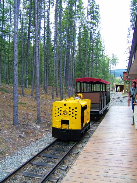
This afternoon, we went out to the Copperbelt Mining and Railway Museum. In 1898, while most people with visions of wealth headed north to the Klondike gold fields, two men investigated rumors of copper in the Whitehorse area. The copper rush their claim produced made Whitehorse more than just a staging ground for the gold fields. After viewing the museum, we took a ride on the rails. The park, envisioned as a future copper-themed park, includes a mining train that circles the ten acre park. The engines are genuine Austrian-built mining engines called “Lo-kies.”
Whitehorse–Monday, August 10, 2009
We stayed over in Whitehorse an extra day to relax and see a few sights. This afternoon we headed over to the Yukon Museum of Transportation, which was surprisingly interesting. We enjoyed all the history of the Yukon – told through its aviation history (bush pilots) and the river and rail history (gold fever and mining endeavors). Before going back the trailer, we ran a couple of errands and then after dinner we watched a movie, “Faith Like Potatoes,” based on the true story of African evangelist Angus Buchan.
Whitehorse to Skagway–Tuesday, August 11, 2009
We returned to Alaska today – to Skagway – for a few days. The drive had some beautiful scenery – especially the lakes – and the rain mostly held off, although Summit Pass was heavily fogged in. We stopped in the historic town of Carcross on Lake Bennett for lunch and wandered about a couple of shops and the historic train station.
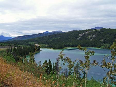 On the road to Skagway: Emerald Lake |
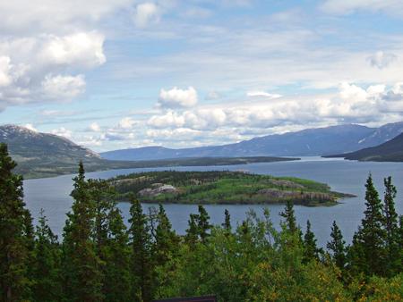 On the road to Skagway: Bove Island |
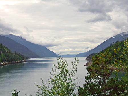
Much of our route paralleled the trail many of the Klondike miners took in 1898. From Skagway or the neighboring port city of Dyea, they climbed either the White Pass or Chilkoot Trail to Lake Bennett, where they built boats to travel the waterways north to the Klondike goldfields. The White Pass and Yukon Route (WP&YR) railroad followed closely behind the early the miners across White Pass, and the road into Skagway hugs the opposite wall of the valley.
We were in Skagway on our cruise nine years ago. We enjoyed the historic flavor of the town’s gold rush past then, but what I didn’t realize then was that the town and the area are actually a national historic park encompassing parts of the town, the Chilkoot Trail, the ruins of Dyea, and the path of the WP&YR. On our drive into Alaska, we stopped at the town ruins of Log Cabin, part of the Canadian National Historic Park honoring miners who had to stop for customs as they crossed the border on their travels up the Chilkoot Trail.
Arriving mid-afternoon, we headed into town to check out both the visitors’ center and the national park visitors’ center, and to get some information on both the WP&YR scenic train (which we enjoyed nine years ago) and a day cruise for Thursday. Mission accomplished, we joined the throngs of tourists from the three huge cruise ships in town and did a bit of shopping. Town was bustling – much more so than we remembered. I think there are more – and larger – ships in port today.
Skagway–Wednesday, August 12, 2009
It rained during the night and was cloudy this morning (It reminded me of Homer, with wispy clouds in a fjord setting but mountains towering above the clouds.), so we hoped it would clear so we could see some of the breath-taking views we remembered from nine years ago. We weren’t disappointed!
Mid-morning we headed out to Dyea for a ranger-led tour of the town site ruins. We continued to learn a lot about the stampeders and their race to the gold. On our way back into town, we stopped at some viewpoints overlooking the Skagway harbor. At one of them, we ran into a tour group off a ship and talked with some ladies from Lincoln, CA. (I don’t think they knew you, Mom and Dad.)
 Dyea was situated on the Taiya Inlet |
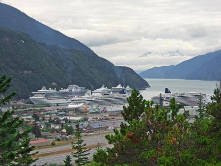 Bustling Skagway on the Lynn Canal |
After lunch, we headed into Skagway to continue our gold-rush history lessons. After purchasing tickets for the evening White Pass & Yukon Route (WP&YR) scenic train, we headed back to the Gold Rush National Historic Park visitors’ center where we watched a film on the gold rush and then joined a ranger-led walking tour through historic Skagway.
Taking a picnic lunch, we boarded one of two WP&YR trains headed for White Pass Summit. This route, which roughly parallels the White Pass Trail, follows the historic train route built during the Klondike gold rush era. Although the two-year gold stampede ended by the time the railway was completed, it was used by mining companies and quickly gained a reputation for its scenic beauty, as it still carries passengers high above the Lynn Canal to look back down at Skagway.
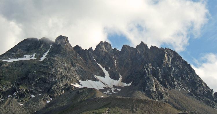 Sawtooth Mountains seen from WP&YR scenic train |
Skagway–Thursday, August 13, 2009
Today was our second long day in a row. We were up by 6 a.m. to be able to catch a day cruise down the Lynn Canal to Juneau and back. The catamaran Fjordlands had smooth sailing on the Inland Passage. After picking up more passengers in Haines, half an hour south, the 40 quite-international group of passengers and our crew of two headed out to find some wildlife on our journey south. We were lucky and spotted several bald eagles, Dall porpoises, harbor seals, stellar sea lions, and a grizzly fishing for salmon at the mouth of a river on shore. The only thing missing was a whale.
 Haines, AK nestled beneath the Chillkat Mountains |
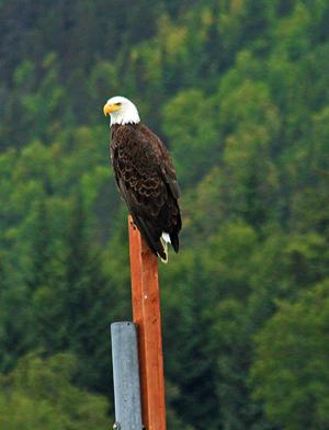 Eagle guards Haines Harbor |
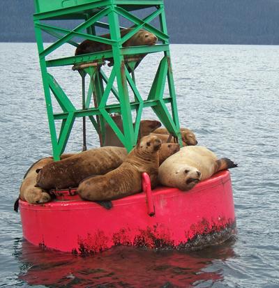 Bunkmates: Harbor Seals and a Sea Lion |
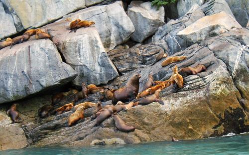 Steller Sea Lions |
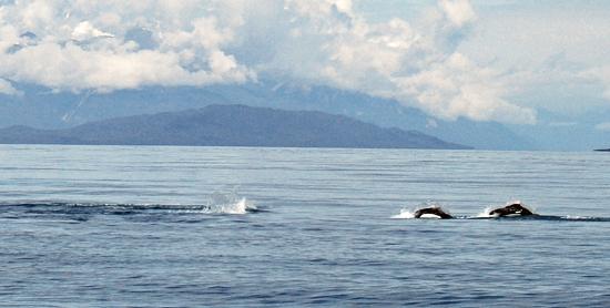 Frolicking Dall Porpoises |
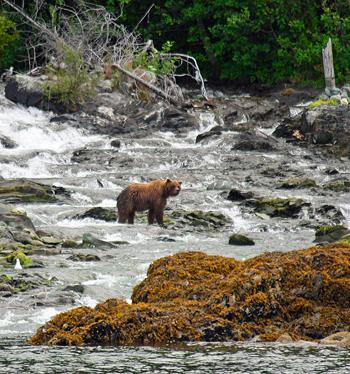 Bear fishes for salmon |
Arriving at a small harbor north of Juneau, a tour bus met us to take us the last few miles into the city. Following a quick tour of the historic area, we had several hours on our own. After lunch at a tasty Mexican restaurant, Tom and I poked through some tourist/souvenir shops. We couldn’t think of anything else to do. (In hindsight, we should have taken the tram up Mt. Roberts, but we forgot about that option until too late.) Tom wanted a recording of me saying I was tired of “shopping,” but we both were so we sat in the park awhile waiting for the bus.
On the way back to the ship, the tour guide dropped us at Mendenhall Glacier for a brief visit. Since my great-grandmother was a Mendenhall, I have always felt an connection to the glacier. It has retreated noticeably since we were there nine years ago.
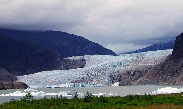 Mendenhall Glacier |
Back on the ship, the first order of business was to find whales. The captain “had heard a rumor” about some humpbacks to the south, so we went in search of them before heading back north to Skagway. We chased them around a bit and waited to see them surface. As always, they are magnificent, but you see just a little portion of their dorsal fin – and no flukes.
We were served a light dinner – clam chowder, a multigrain roll, and a cookie; yes, I eat clam chowder (Tom doesn’t), even though neither of us particularly cares for fish. It was a pretty view of the mountains and water as we cruised into the darkening skies to Skagway. It was almost 9 p.m. by the time we made it back to Skagway, and we want to get an early start tomorrow to make it all the way to Watson Lake.
Skagway
to Watson Lake–Friday, August 14, 2009
We got up early and got on the road, as we had about 300 miles to Watson Lake and we lost an hour. (Alaska is one hour ahead of California.) The drive was pretty, but cloudy as we headed back up the White Pass and crossed into Canada. (At least we had the views in Skagway.) We took the Tagish cut-off over to the Alaska Highway at Jake’s Corner. Along the way, we saw a black bear across the river bordering the road.
Shortly, after reaching the Alaska Highway, we stopped for lunch, and then had smooth cruising south to Watson Lake. We found a bit of smoke in the Teslin area, so it wasn’t quite as pretty as it had been on our drive north. The bonus of the day was the sighting of a mama bear and three cubs who ran across the highway ahead of us.
Arriving and settling in Watson Lake, we then returned to the visitors’ center to turn in our “Yukon passports.” The Ministry of Tourism and Culture sponsored a contest this summer for visitors. We received “passports” on our drive north and collected stamps at various tourist destinations in the Yukon. Obtaining 22 of 31 possible stamps, we received souvenir Yukon pins and have been entered in a drawing for gold. It added to the fun and adventure, as we visited the sights and tried to collect the stamps.
We then picked up a few grocery items, caught up on e-mail and journals, and went to dinner at a truck stop called BJ’s. Small, with slow service, but interesting experience. I heard the couple at the next table introduce themselves to another couple from Switzerland. When they said they were from Auburn, CA, I leaned over and said we were from Folsom – neighbors.
Watson
Lake to Iskut –Saturday, August 15, 2009
We began the Cassiar Highway, a windy, rough road through some pristine wilderness areas south to Iskut today. We traveled 200-plus miles on a mostly paved narrow road with sections of gravel and construction. At one point, we had to wait half an hour for a pilot car to lead us through a portion. My overall impression is one of peaceful lakes, rolling foothills, winding mountain roads and thick forests. Now at the Mountain Shadow RV Park, it is quiet and peaceful, although drizzle earlier in the day has developed into rain this evening.