Becky's Journal - July 26 - August 1
On the Road: Valdez and Kennecott
Glacier
View to Valdez – Sunday, July 26, 2009
Spending Saturday night half way between Homer and Valdez, we awoke to clear skies and beautiful views of the Chugash Mountains. Hitting the road, we had clear skies to the south, but cloudy skies ahead to the east. The drive – dotted with mountain vistas, wayside lakes, rivers and forested and meadowed expanses – was a feast for the eyes. The immensity, solitude, and shear grandeur cannot be captured in photos.
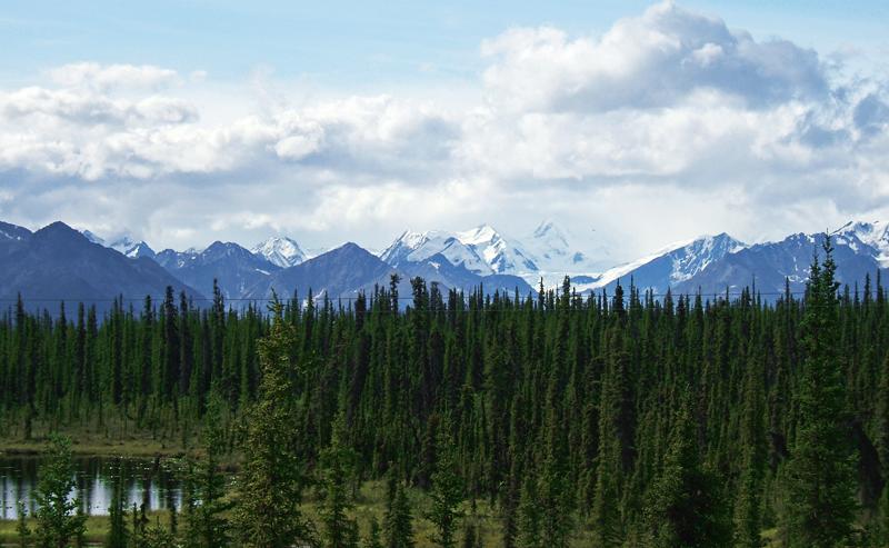
As we approached Glennallen, gateway to the Wrangell-St. Elias National Park, we could see the middle third of these immense mountains, shrouded by clouds in the valleys and clouds at their highest reaches. Hopefully we will get a better view on our return from Valdez.
As we turned south to the coastal town of Valdez, we stopped at the national park visitors’ center for lunch and a 20-minute film on the park, which whetted our appetite to explore further in this wilderness park six times the size of Yellowstone National Park. Spanned by four mountains ranges – the Alaska Mountain Range, the Chugach Mountain Range, the Wrangell Mountain Range, and the St. Elias Mountain Range – Wrangell-St. Elias boasts nine of the 16 highest peaks in the United States and the greatest concentration of glaciers in North America.
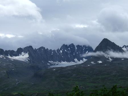
We’ll be back this way, so we continued southward to Valdez, known as the Switzerland of Alaska. The road, though cloudy, was still gorgeous, as we wound through mountain passes, past the Worthington Glacier and Horsetail Falls. As we topped Thompson Pass, we were enveloped in the clouds, until we descended into the valley where Valdez is.
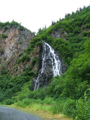 Horsetail Falls |
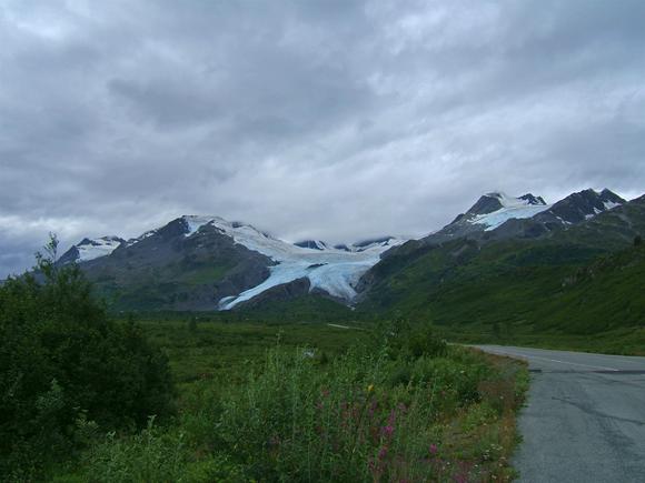 Worthington Glacier |
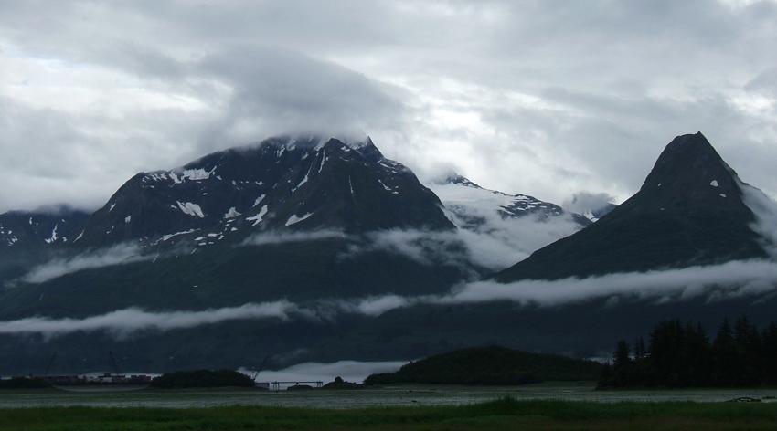
Valdez reminds me very much of Seward – rainy, cloudy harbor town, surrounded by tall mountains shrouded in clouds. We’ll spend a couple of days exploring, but won’t head out on a cruise of Prince William Sound with the weather as it is. Valdez is the terminus of the Alaska Pipeline, and is known for the 1989 Exxon oil spill. Valdez, destroyed by the 1964 Good Friday earthquake and tsunami, was rebuilt four miles away.
Valdez –
Monday, July 27, 2009
Drizzly and fog shrouded this morning, so we took it easy and examined options for our time later this week in Chitina. The weather outlook is improving Wednesday and Thursday, so we made reservations to fly into Kennecott Mine in the national park on Thursday.
After lunch we headed to the local visitors’ center to find out more about attractions in Valdez. We visited a gift shop that offers free movies on the earthquake and the building of the pipeline (a good idea to keep the non-shoppers busy, while the shoppers shop.) The pipeline DVD was more technical than my tastes, so I did some shopping, but I enjoyed the piece on the earthquake, especially now being familiar with many of the places named. We took a short (149 stair steps) climb up to an overlook of the town and harbor in the drizzle, and then stopped at the grocery store before heading back to the trailer.
 Valdez
– Tuesday, July 28, 2009
Valdez
– Tuesday, July 28, 2009
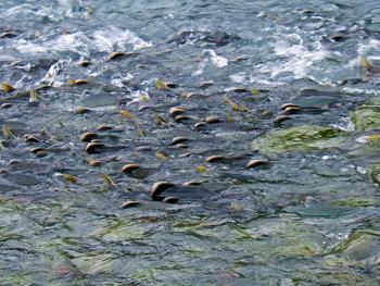
The clouds lifted slightly to allow us a partial view of the surrounding mountain splendor. After lunch we drove out to a few sites near Valdez. First we headed to the Crooked Creek information station to view spawning salmon. Then we made a stop near the old town site – destroyed by the 1964 earthquake and tsunami. Finally, we drove out Dayville Road to the entrance of the Alyeska Pipeline terminus. (Since 9/11, you can’t drive any further.) On the way, we stopped to see some spectacular scenery, and hundreds of salmon struggling to make it upstream from the shoreline. Bears are often seen in this area, but we weren’t fortunate to see any today. We did enjoy watching the salmon and the gulls who delighted in riding the rapids downstream.
Valdez to
Chitina – Wednesday, July 29, 2009
We woke up to relatively clear skies, but then the clouds came back in with drizzle. With fewer than 100 miles to travel today, we delayed starting out until nearly noon. As we drove up the valley and wound our way up to Thompson Pass, wonder of wonders, the skies cleared and we had some breathtaking mountain views.
 |
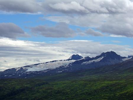 |
Near the summit, we stopped for lunch and ambled out on a promontory access road to gain some top-of-the world views. Beautiful! A bit later, we stopped and walked out to Worthington Glacier – much better visibility than on our trip down to Valdez.
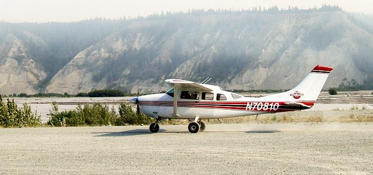
Late afternoon, we arrived in Chitina (pronounced Chit-na), a small town on the edge of Wrangell-St. Elias National Park and Preserve, and camped in a rustic park near the airport. We drove by the airport to check out Wrangell Mountain Air and watched the 5:30 plane land. (We are taking Wrangell Mountain Air into the park tomorrow.) Then, we drove into the small town of Chitina and to the edge of the national park. There is a rutted, narrow, gravel road that leads 50 miles into the park to McCarthy, but we elected to see the sights from the air instead of bouncing on the road.
Kennecott
– Thursday, July 30, 2009
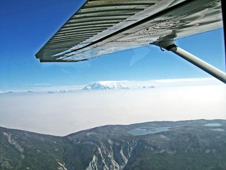
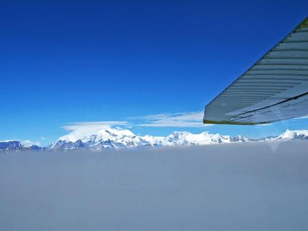
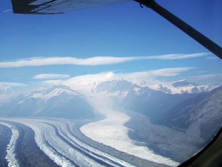
We were up early to be at the airport for a 9:00 flight. About 18 of us waited and waited and waited at the small deserted airport. With a forest fire burning in the park, we knew the flights had been running late the day before, so we waited an hour until the small planes arrived to ferry us into the park. Tom and I joined a couple from Maryland and a young man from the Netherlands for our 35-minute flight to McCarthy/Kennecott.
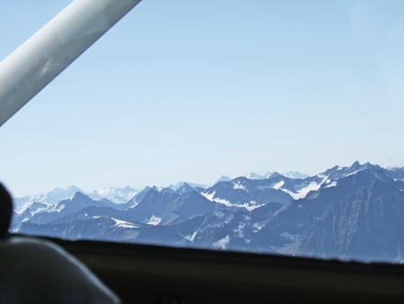
With the smoke and fire we weren’t sure what we’d see from the air. Although the valley was mostly obscured by smoke, the peaks of Wrangell-St. Elias shone majestically above. Our pilot provided an interesting narrative on the peaks, volcanoes, and glaciers as we flew. Pictures don’t do the sights justice. It was amazing!
 |
 |
 |
 |
Landing at the airport in McCarthy, the passengers went their own ways. Some planned to stay at the lodge for an extended period, some had a glacier excursion planned that afternoon, some continued on to flight see, and others, like Tom and me, went on to Kennecott, a national historic landmark within the national park.
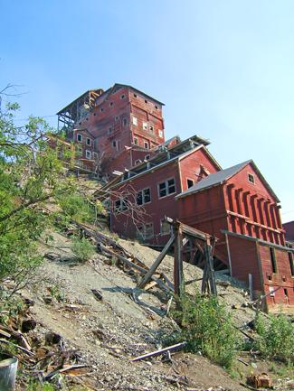
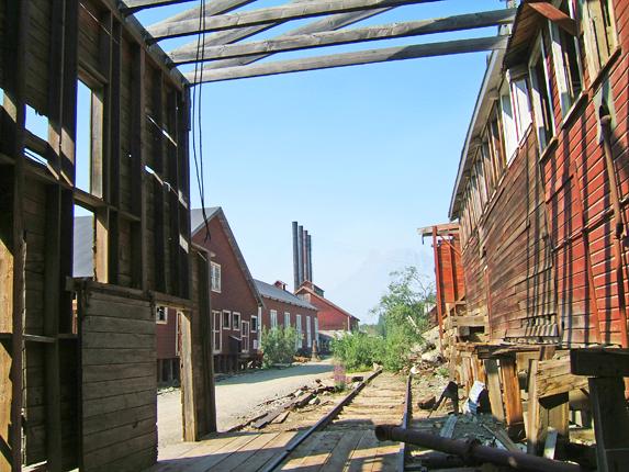
After lunch at the Kennicott Glacier Lodge, we went on a guided tour of the now-deserted copper mines. (Although the mines and mill town were named for the neighboring Kennicott Glacier, the mining company spelled its name with an “e,” and the spelling debate continues even today.)
 |
 |
Prospectors in 1900 were exploring the east edge of the Kennicott Glacier and were amazed at the green cliffs of green copper. Their discovery yielded one of the richest copper deposits ever found. Three wealthy families, including J.P. Morgan and the Guggenheims formed the Alaska Syndicate to develop the mines. The Kennecott Copper Corporation mined these hills until 1938 and is still actively mining in other areas of the world.
The miners lived an isolated, grueling life in a “dry” mill town. McCarthy developed to provide for the seamier sides of life. Only upper management was allowed to have families with them in town. Our tour took us into the buildings in the town, including the mill itself, where we hiked up and down steep steps to discover what life might have been like for those early miners and how the ore was processed.
Once the mill tour was over, Tom and I took the shuttle over to McCarthy. Not finding much in the small, secluded town, we settled for ice cream as we waited to return to the airport for our return flight. The smoke had lifted some, but the clouds had come in as well, so our return trip didn’t seem as spectacular as our first flight.
We enjoyed seeing the town and mill of Kennecott, Kennicott and Root Glaciers, and the majestic, towering mountains, including Mt. Wrangell and Mount Blackburn.
Chitina
to Tok – Friday, July 31, 2009
Skirted Wrangell-St. Elias National Park for most of our drive today. The clouds and smoke cleared some, so we were able to see partial views of Mounts Drum and Sanford. We stopped again at the main park visitors’ center near Glennallen and then had lunch at the ranger station near Slana, the gateway to the northern access point to the park. A wilderness park, access is gained mostly by flying in. Two gravel roads – one from Chitina to McCarthy and the second from Slana to Nebesna provide the only entrée most tourists have into the park. Had it been clearer, we would have dropped the trailer at the ranger station and driven partway on the Nebesna Road. Instead, we continued on the hour more to Tok on the Alaska Highway, where we will spend a couple of days catching up and doing some laundry and shopping.